21 Point Geo Grid to Simulate Location Searches for Agencies
21 Point Geo Grid to Simulate Location Searches for Agencies

Simulating a location search means viewing Google Search and Maps results exactly as a searcher in a specific spot would see them, factoring in the distance-based ranking shift Google applies to every query. For agency work, the direct approach is a geo-grid rank tracker covering multiple points across a client’s service area, with manual VPN spot checks on 3 to 5 of those points to confirm the data holds up. The output you want is a neighborhood-level visibility map you can hand a client and explain clearly in a short amount of time.
TL;DR:
- Manual methods like VPNs and Chrome DevTools provide quick checks but lack the scalability needed for ongoing client reporting.
- Geo-grid rank trackers allow simultaneous simulated searches across multiple points, making large-area audits and recurring reports feasible.
- Accurate setup involves choosing the right center point, grid shape, spacing, and keywords, with baseline grids around 21 points for most local audits.
- Verify scan data through manual spot checks at different points; discrepancies over five positions or missing data indicate the need for reruns or troubleshooting.
- Deliverables should include overall coverage, heatmaps, neighborhood-specific rankings, and a ranked fix list to guide client action plans effectively.
Table of Contents
- What Simulating a Location Search Actually Changes
- Manual Checks vs. Geo-Grid Tools: Which One Actually Scales
- Setting Up a Geo-Grid Scan That Actually Tells You Something
- Verifying Your Scan Data Before You Trust It
- Turning Grid Results Into a Client Action Plan
- Setting Realistic Expectations With Local SEO Clients
- Run Your Next Geo-Grid Scan Without the Per-Location Markup
- Sources
- FAQ
What Simulating a Location Search Actually Changes
When you simulate a location search, you’re recalculating the searcher’s distance from every nearby business and letting Google recompute the results from that new point. Google’s own guidance lists relevance, distance, and prominence as the three factors driving local search rankings, and distance is the one that shifts hardest between two addresses a mile apart.
This is why a single rank check from your office is close to useless for client reporting. Google Maps runs on a layered system, Geostore, Oyster Rank, and Mapcore among the components, and geography gets applied dynamically enough that it can change which businesses even show up as candidates, not just their order in the list. A dentist can hold the third map pack spot two blocks from their office and disappear entirely six blocks north. That drop is a visibility cliff, and it’s the whole reason grid testing exists.

Manual Checks vs. Geo-Grid Tools: Which One Actually Scales
Two broad paths exist for testing location-based rankings, and they solve different problems.
Manual methods work fine for a quick gut check:
- A VPN set to a nearby city combined with an incognito browser window, though most consumer VPNs snap to city-level IP blocks, not the street-level precision agencies need.
- Chrome DevTools’ sensor panel, which lets you override geolocation coordinates directly, useful for testing but clunky for anything beyond a handful of points.
- Asking a local contact to run the search from their phone, which is accurate but obviously doesn’t scale past one or two spots.
Geo-grid rank trackers solve the scaling problem by running dozens of simulated searches simultaneously across a mapped grid. When you’re auditing a client’s whole service area or producing a recurring monthly report, grid-based tracking beats manual VPN checks on repeatability alone, you can’t manually recreate the same 21 test points every month without it becoming a part-time job. Prioritize tools that offer customizable grid shapes, white-label reporting you can put your own agency’s name on, unlimited tracked businesses so pricing doesn’t punish growth, and no requirement to connect a client’s Google Business Profile account.
Pro Tip: Keep manual checks in your workflow permanently, not as a backup plan. Even the best grid tool benefits from a human spot check before a number goes into a client deck.
Use manual methods for one-off questions a client emails you about. Use a tracker for anything recurring, anything you’re billing hours against, or anything that needs to scale across multiple clients.
Setting Up a Geo-Grid Scan That Actually Tells You Something
Getting a scan you can trust starts before you click “run.” The setup decisions you make here determine whether the output is useful data or a colorful map that means nothing.
- Pick your center point. Use the exact business address for a storefront. For a service-area business with no public storefront, center the grid on the geographic centroid of the area they actually serve, not their home office if that’s different.
- Choose grid shape and spacing. A tight urban grid works at half-mile spacing; a typical suburban setup runs about 1 mile between points; rural service areas need wider spacing to avoid wasting scan credits on empty stretches of highway.
- Set a minimum grid size. A 21-point grid, arranged in a focused pattern around the center, is a practical baseline for most audits, dense enough to catch a visibility cliff without burning excessive scan credits.
- Select your keywords. Choose 3 to 7 terms that mix high-intent commercial searches (“emergency plumber near me”) with straight category and brand terms (“plumber,” the business name).
- Set scan depth and cadence. Track the top 10 or the map pack specifically, run active campaigns monthly, and drop to quarterly once a client hits maintenance mode.
For every scan, capture these outputs for the client file:
- Overall grid coverage percentage
- A visual heatmap by ranking position
- Top-3 share broken down by neighborhood
Pro Tip: Run your first baseline scan before making any changes and screenshot it. Clients forget where they started, and a “before” map is the easiest way to prove six months of work actually did something.
Verifying Your Scan Data Before You Trust It
Before any grid output goes into a client report, run it through a quick reality check. Grab three points from the grid, one close to the business, one at medium distance, one at the edge, and manually verify each using a VPN set to that location plus an incognito browser. If the manual result and the grid result land within a position or two of each other, the scan is trustworthy.
Watch for these red flags:
- Fewer than half the grid points return any ranking data at all, which usually points to scan settings, not actual invisibility, since under 50% population typically signals a technical issue.
- Manual spot checks disagree sharply with the grid, off by five or more positions.
- The business shows a Google Business Profile verification warning or a pin sitting on the wrong street.
If results still look off after the spot check, rerun the scan at a different time of day, engagement patterns like calls and direction requests shift throughout the day, then confirm the pin sits on the correct building before assuming the ranking itself is the problem.
Turning Grid Results Into a Client Action Plan
Raw grid data is a map with colors on it. The value comes from reading the patterns and turning them into a short list of fixes a client can actually approve.
Three patterns show up again and again:
- Visibility cliffs, where rankings hold strong for a mile then vanish entirely, usually mark a distance eligibility boundary rather than a content problem.
- Competitor clusters, where the same two or three businesses dominate every point in one neighborhood, point to prominence gaps you can chase with reviews and local links.
- Engagement-driven winners, businesses that rank above their proximity would suggest, often owe it to strong click and direction-request volume rather than optimization.
Each pattern maps to a different fix: geo-targeted review requests to close prominence gaps, neighborhood landing pages with proper areaServed schema for cliffs near a boundary, local backlinks from community sites to build prominence, and pin corrections when the data itself looks wrong before anything else.
| Client deliverable | What it shows | Priority level |
|---|---|---|
| Coverage percentage | Share of grid points where the business appears at all | Baseline metric, report every cycle |
| Heatmap by position | Visual read of where rankings are strong vs. weak | Quick win for client presentations |
| Top-3 share by neighborhood | Which specific areas hold map pack visibility | Core metric for prioritizing fixes |
| Prioritized fix list | Ranked actions from quick wins to longer-term investments | Drives the next month’s work plan |
Quick wins, fixing a pin, requesting reviews from a specific neighborhood, cost little and often move the needle inside a month. Longer investments, like building out neighborhood pages or earning local backlinks, take quarters to show up on the grid but tend to hold once they land.
Setting Realistic Expectations With Local SEO Clients
Distance is the variable most clients underestimate. A business three miles from a searcher is fighting physics, not just competitors, and no amount of content fixes that gap overnight. What optimization actually does is widen the radius where a business stays competitive, incrementally, through prominence signals like reviews and links rather than by overturning the role distance plays.
Set reporting cadence to match campaign stage: monthly grid scans for clients in active optimization, quarterly for accounts in maintenance mode where you’re mainly watching for drift. Show clients the same grid twice, once at the start and once three months later, and the incremental radius expansion becomes the easiest thing you’ll ever explain in a client call.
— Local
Run Your Next Geo-Grid Scan Without the Per-Location Markup
Some rank trackers charge per tracked location or bury pricing behind sales calls. Some tools offer unlimited trackable businesses, customizable grid sizes and spacing, and white-label reports you can brand, without the need to connect any client’s Google account.
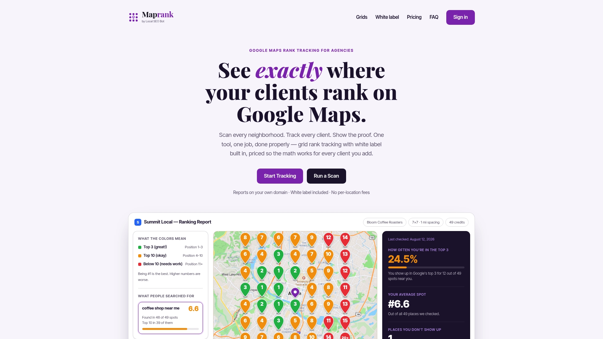
Agencies typically pull a baseline grid scan for a new client audit, then schedule recurring scans to feed monthly reports that show coverage percentage, the ranking heatmap, and top-3 share by neighborhood side by side. If you’re running client audits regularly, Maprank Solo through Maprank Scale scale by scan credits and seats, not by how many businesses you track. Not ready to commit to a plan? Run a one-off rank check on a single client first and see the grid output for yourself before deciding how it fits your reporting workflow.
Sources
Google’s own local ranking factors page and Search Engine Land’s Maps architecture breakdown cover the technical side. For grid mechanics, see GMBMantra’s practical guide and Moz’s proximity summary.
- Inside Google Maps: 72 ranking signals and the architecture behind local search — Search Engine Land
- How to Check Where Your Business Ranks on Google Maps — From Your Customer’s Location | GMBMantra
FAQ
What Does It Mean to Simulate a Location Search?
It means viewing Google Search or Maps results as if you were searching from a specific address rather than your own location, which recalculates the distance factor Google uses in local rankings. Agencies do this to audit how a client actually appears to searchers in different neighborhoods.
How Many Grid Points Do I Need for an Accurate Scan?
A 21-point grid is a workable baseline for most local audits, with denser spacing in urban cores and wider spacing in rural service areas. Fewer points can miss visibility cliffs that a low-density scan won’t catch.
Can I Simulate Location Search Manually Without a Tool?
Yes, using a VPN set to a target city combined with an incognito browser window, or Chrome DevTools’ geolocation override for developer-level precision. Both work for spot checks but don’t scale past a few points, which is why recurring client reporting relies on grid-based tracking tools instead.
How Often Should Agencies Run Geo-Grid Scans?
Monthly scans fit clients in active optimization, while quarterly scans suit accounts in maintenance mode where you’re mainly watching for drift. Consistent cadence also makes before-and-after comparisons easier to show in client reports.
Does Maprank Require Access to a Client’s Google Account?
No. Maprank runs grid scans without connecting to a client’s Google Business Profile, and every plan includes unlimited trackable businesses and white-label reporting. Current pricing and plan details are listed on the Maprank site.