Lock Scan Radius Settings for Agencies: Start With a 5×5 Grid
Lock Scan Radius Settings for Agencies: Start With a 5×5 Grid
Scan radius is the distance from each point in your ranking grid to the edge of the area Google Maps checks when it decides which businesses show up in local results. The rule of thumb: tighten the radius for dense urban clients where competitors sit blocks apart, and widen it for suburban or rural clients whose customers drive miles to reach them. Start with a 5×5 grid at a spacing that matches your client’s actual service footprint, then adjust from there.
TL;DR:
- Using a consistent scan radius aligned with the client’s market density is crucial, with less than a mile for dense urban areas and several miles for rural zones.
- Lockting in your grid size, radius, and center point after initial calibration ensures comparability in long-term tracking and avoids misleading fluctuations.
- Adjusting the radius midway through a campaign creates data inconsistencies, so testing multiple radii in the beginning helps determine the optimal setting.
- Applying a wider radius in dense markets blurs neighborhood differences, while a narrow radius in rural areas risks missing key competitors in the coverage area.
- Prioritize keywords and areas that significantly impact the client’s revenue and avoid wasting credits on zones with little or no competition.
Table of Contents
- What Scan Radius Actually Controls in a Rank Scan
- How Radius, Grid Size, and Market Density Work Together
- Recommended Scan Radii by Market Type
- How to Calibrate and Lock the Right Scan Radius
- Common Scan Radius Mistakes That Wreck Your Data
- Centering the Grid for Service-Area Businesses
- Credits, Consistency, and What Belongs in a Client Report
- Where I’d Spend the Scan Credits First
- Run Consistent Scans Without the Guesswork
- Sources
- FAQ
What Scan Radius Actually Controls in a Rank Scan
A geogrid scan runs a rank check for one keyword at every point in your grid, and radius determines how far Google’s local algorithm reaches from each of those points before it decides who ranks. Change the radius, and you change which competitors get pulled into the comparison at every single point.
This matters because Google’s local results lean heavily on proximity. A business three blocks from a grid point in Chicago’s Loop competes in a completely different pool than one three miles out. Set the radius too tight in a spread-out market and you’ll miss real competitors hiding just outside your scan lines. Set it too wide in a dense downtown corridor and you’ll blur neighborhood-level detail into a mush of averages that hides exactly the block-by-block variation your client is paying you to find.
A landscaper covering a whole county needs a wide radius to see the real competitive picture. A dentist competing against three other practices on the same avenue needs a tight one.
How Radius, Grid Size, and Market Density Work Together
Radius never operates alone. It works in tandem with grid size, and the combination decides both your diagnostic resolution and your bill. A 3×3 grid gives you 9 rank checks, a 5×5 gives you 25, and a 7×7 balloons to 49. Each additional point costs credits and processing time, so the question isn’t “bigger is better,” it’s “what does this client’s market actually need.”
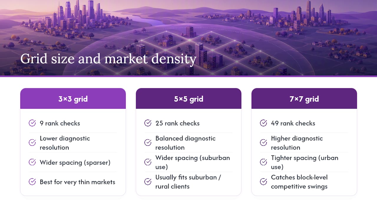
Dense urban markets usually call for more grid points packed into a tighter radius, because competitive shifts happen over a few hundred feet as detailed in Local SEO NYC: A neighborhood-by-neighborhood playbook. Grid density and radius together control diagnostic quality. An urban 7×7 with tight spacing catches the block-level swings a sparser grid would completely miss. Suburban and rural clients flip that logic. Their competitive landscape is thinner and more spread out, so a 5×5 grid with wider spacing usually covers the territory without wasting credits on redundant points a mile apart that would return nearly identical results anyway.
The mistake agencies make most often is defaulting to the same grid and radius for every client. A geo grid rank tracker is only as useful as the geography it’s actually built to match.
Recommended Scan Radii by Market Type
Here’s a starting reference for calibrating new client scans. These are baselines, not fixed rules. Treat them as your first pass, then adjust after you see the actual heatmap.
| Market type | Recommended grid | Recommended spacing/radius |
|---|---|---|
| Dense urban | 7×7 | typically less than a mile between points |
| Urban | 5×5 | about one mile or less between points |
| Suburban | 5×5 | over one mile between points |
| Rural / wide service area | 3×3 to 5×5 | several miles between points |
That guidance comes from practical geogrid density and radius diagnostics built for exactly this kind of calibration work. One caution: pick miles or kilometers and stick with it across every scan for a client. Switching units mid-engagement is a fast way to hand a client a heatmap that looks like it shrank or grew for no reason, when really you just converted wrong.
How to Calibrate and Lock the Right Scan Radius
Getting the radius right takes one afternoon of testing before you commit to a client’s ongoing tracking setup.
- Map the client’s real service geography. Pull their service area, their busiest ZIP codes, or their delivery radius, not just their street address.
- Run a baseline 5×5 scan at the spacing your market type suggests from the table above.
- Run a second scan at a different radius, wider or tighter, on the same keyword and center point.
- Compare the two heatmaps for proximity cliffs. A client that ranks well at 0.5 miles but drops off hard at 2 miles has weak authority projection, and comparing radii is how you catch that instead of guessing at it.
- Lock the configuration you’ll use for every future scan on this client. Write it down.
- Document the exact grid size, spacing, center point, and date in the client’s file before you move to monthly or quarterly tracking.
Skipping step 5 is how agencies end up with three months of “trending” data that’s actually just noise from three different radius settings.
Common Scan Radius Mistakes That Wreck Your Data
Most radius problems aren’t complicated. They’re just habits that quietly break comparability over time.
- Using the client’s office address as the grid center for a business that mostly serves customers elsewhere.
- Changing the radius between monthly runs, which makes each scan incomparable to the last even if nothing in the client’s rankings actually changed.
- Running a wide radius in a dense downtown market, which flattens real block-level competition into meaningless averages.
- Running a narrow radius in a rural market, which leaves most of the service area unmeasured.
- Treating one red grid point as a confirmed dead zone instead of checking whether it’s an outlier from a single scan.
Pro Tip: Before you touch radius settings for an existing client, pull their last three scans and check whether anyone changed spacing between them. You’d be surprised how often a “ranking drop” is actually a settings change nobody documented.
Centering the Grid for Service-Area Businesses
An office address is a terrible stand-in for where a mobile business actually competes. A plumber based on the edge of town but serving the entire metro area will get a scan grid that’s half wasted on farmland if you center it on their street address.
Instead, estimate the geographic midpoint of the client’s real coverage zone using their service ZIP codes or the areas where they get the most job requests. Centering on that midpoint instead of the office produces a heatmap that actually reflects where their customers search from, not where their van happens to park at night.

Credits, Consistency, and What Belongs in a Client Report
Tighter grid spacing means more points, and more points mean more API calls, more processing time, and more credits burned per scan. That’s fine when you’re troubleshooting a specific problem. It’s wasteful as your default setting.
- Keep the same grid size, radius, and center point every time you track a given client, so month-to-month comparisons mean something.
- Reserve a denser, layered scan (7×7 or 9×9) for one-time troubleshooting, not routine tracking.
- Record the grid size, radius, center point, scan date, and target keywords in every report you hand a client, especially white-labeled ones where they can’t ask you a follow-up question mid-review.
Agencies using a tool like Maprank can save these configurations per client so nobody on the team accidentally reruns a scan with mismatched settings six months later.
Where I’d Spend the Scan Credits First
If a client’s budget only covers baseline tracking, spend it on the keywords that drive revenue and the neighborhoods where rankings are genuinely contested, not on blanket coverage of areas with no real competition. Run 5×5 as your default and only layer in 7×7 or 9×9 when a client specifically needs to settle a dispute about one corridor. Tell clients plainly that a wider grid costs more credits for a reason, not as an upsell.
— Local
Run Consistent Scans Without the Guesswork
Maprank is built around the exact problem this article covers: getting radius and grid settings right, then keeping them locked so your reports mean something over time. You set the grid size and spacing yourself for each client, save that configuration, and every future scan runs against the same benchmark automatically, no re-entering settings and no wondering if last quarter’s numbers used a different radius.
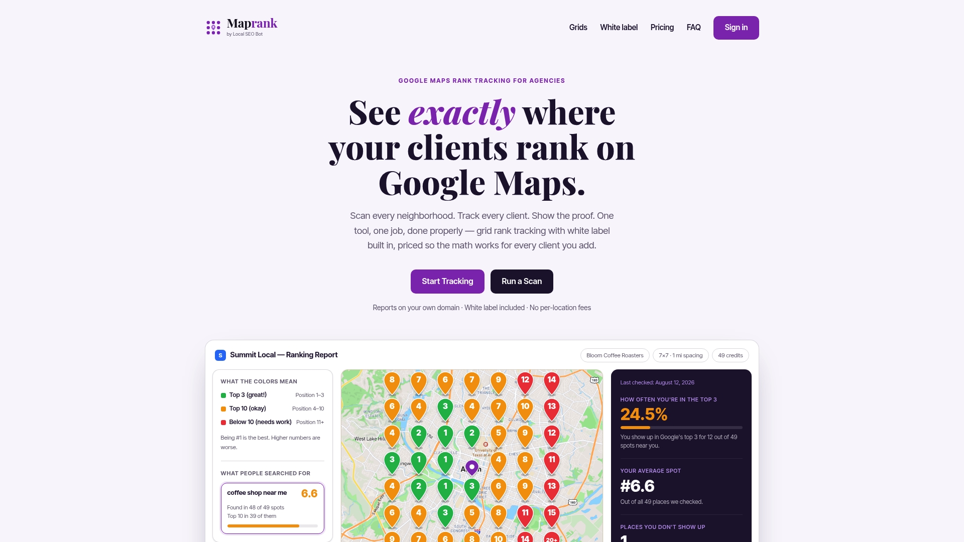
There’s no Google account integration required, and pricing runs on straightforward per-scan credits rather than per-location fees that punish you for adding a new client. White-label reporting means the heatmap, grid size, and radius notes go out on your own branding, not Maprank’s. If you want to see how a properly calibrated scan actually looks before committing to a plan, run a one-off diagnostic scan on a current client, or check the full plan lineup starting at $19 a month for solo consultants and scaling up for agencies managing larger rosters.
Sources
FAQ
What Unit Should I Use for Scan Radius?
Use whichever unit, miles or kilometers, matches the client’s own market conventions, and keep it identical across every future scan for that client. Mixing units between runs makes heatmaps look like they changed size when nothing about the client’s rankings actually moved.
Does Scan Radius Need to Change by Keyword?
Usually not within the same client, since most keywords describe the same core service area. The exception is a client with genuinely different service zones for different offerings, where running separate grids per keyword category gives a more honest picture than forcing one radius to cover unrelated markets.
How Often Should I Rerun the Same Scan Radius?
Monthly or quarterly tracking works for most clients, as long as the grid size, radius, and center point stay locked between runs. Changing any of those settings between scans breaks the comparison, so consistency matters more than frequency.
Can I Use a Different Radius for Troubleshooting Than for Regular Tracking?
Yes. Run your locked baseline configuration for ongoing monthly reports, then layer in a denser, wider, or tighter one-off scan specifically to investigate a problem, like a sudden drop in one neighborhood. Just keep the troubleshooting scan separate from the trend data so you don’t confuse the client’s report.
Does Maprank Let Me Save Radius Settings per Client?
Yes, Maprank allows fully customizable grid sizes and spacing per client, and those configurations save so every future scan runs against the same settings automatically. Pricing details for each plan are listed on the Maprank site.